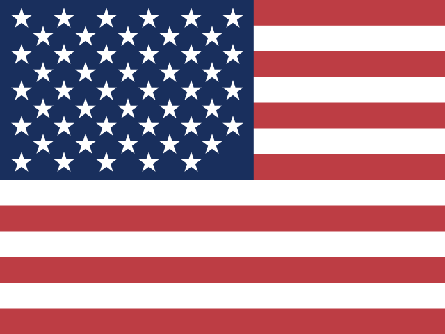
Which country does this flag belong to?
Postcard club
Good eye,
traveller.
0 pts
Which country does this flag belong to?
Postcard club
0 pts
Tap the country on the map. Hover or focus a shape to check its name first. Pinch, scroll, or use the zoom buttons to get a closer look at small countries.
Postcard club
0 pts
Postcard club
0 pts
One country. One click. A world to discover.
This page drops you straight into WorldQuizr's Map Quiz mode: an unlabeled world map, one country named per round, ten rounds per session. It is the same map quiz that lives on the WorldQuizr homepage, just as its own page for anyone who searched specifically for a map quiz rather than a broader geography game. Flag Quiz and Capital Quiz are one tap away in the mode switcher above if you want to try the other two after this one.
Flag Quiz and Capital Quiz are both recognition tasks: you are matching one thing (an image, a country name) against a short list of options. Map Quiz works differently. You are given a name and asked to locate a shape from memory among more than a hundred others, with no list of choices to narrow things down. That is spatial recall rather than pattern matching, and it is a noticeably harder skill for most people to build, which is exactly why a map quiz tends to feel like the toughest of the three modes here.
The difficulty is not spread evenly across the map. Large, distinctively-shaped countries (Italy's boot, India's downward triangle, Chile's thin ribbon along South America's west coast) get found quickly even by casual players. The real test is the countries whose shape is unremarkable and whose neighbours are easy to confuse: land-locked blocks in Central Africa, small states packed along Europe's borders, and any country whose outline is mostly a rectangle or a blob with nothing memorable to anchor it.
The world map here carries no country names. That is deliberate: printed labels would turn every round into a reading exercise instead of a memory one. The names stay reachable one hover or one keyboard focus at a time, so you can check yourself before committing to a click.
Country outlines are drawn, and they have to be, because clicking a shape is how an answer is given. People searching for a no borders map quiz usually want the harder variant, where those internal outlines are hidden too and only the coastline remains. This page is not that format, and pretending otherwise would only cost you a round finding out.
A handful of mix-ups show up constantly in Map Quiz results, and knowing them ahead of time removes a lot of the surprise. Niger and Nigeria sit side by side in West Africa, share the first five letters of their names, and get their borders swapped constantly by players moving quickly. Chad, Niger, Mali and Mauritania form a wide, similarly-shaped band across the Sahel that is genuinely hard to tell apart without a reliable landmark to anchor from. The three Baltic states (Estonia, Latvia and Lithuania) are almost always clicked in some scrambled order rather than their correct north-to-south sequence. And the small nations packed into the Balkans and Central America are frequently confused with their immediate neighbours simply because there is so little map space to distinguish one from the next.
Every one of those clusters gets easier once the rest of the world is off screen. The Africa map quiz puts the whole Sahel band on one screen at a size you can actually read, the Europe map quiz does the same for the Baltics and the Balkans, and the Asia map quiz narrows the view to 45 countries, among them the five Central Asian republics whose names all end the same way. Same engine, same click-the-shape rule, one continent at a time.
Small countries are a real usability problem for any clickable map: a country like Luxembourg or Brunei occupies only a handful of pixels at world-map scale, and a strict pixel-perfect hit zone would make them close to unplayable on a touchscreen. WorldQuizr's Map Quiz widens the actual clickable area well beyond each country's visible fill, so tapping close to a small country's true location registers correctly even if your finger lands slightly outside its drawn shape. It is a deliberate accessibility choice, not a bug: the goal is a fair test of whether you know roughly where a country is, not a test of tap precision on a six-inch screen.
A miss is never a dead end either. Click the wrong shape and the game marks it wrong immediately, but it also lights up the actual correct country in full green at the same time, so every wrong guess doubles as an instant, visual correction rather than a mystery you have to look up later.
Each Map Quiz session is ten rounds. Every round names one country and waits for a click anywhere on the unlabeled world map below it. A correct click adds to your score and streak immediately; a wrong click reveals the true location in green, resets your streak, but never ends the session early, so a rough start never costs you the rest of the round. At the end of ten questions you get a results screen with your score, your accuracy as a percentage, and a short review list of anything you missed with the correct country named next to it.
Your best Map Quiz score is saved locally in your own browser, the same as Flag Quiz and Capital Quiz, so you can chase a personal record without creating an account. See the privacy policy for exactly what that local storage does, and does not, touch.
The clickable world map in Map Quiz is built from openly licensed geographic outline data, not a hand-traced drawing, which keeps every country's shape accurate and easy to correct if a border is ever redrawn. 172 countries and territories are quizzable; a small number of additional background shapes (disputed territories and a couple of uninhabited island groups without a clean single-country match) are drawn on the map so it still looks geographically complete, but are never asked about, since the goal is a quiz where every question has exactly one defensible correct answer. If you are also curious how WorldQuizr compares to the street-view guessing format GeoGuessr popularised, the GeoGuessr alternative comparison walks through the honest differences, including where a street-view guesser is genuinely a better choice than a flat map quiz.
Good to know
Same scoring, same no-sign-up rules, two more ways to test your geography.
Free. No sign-up.